|
|
||||||||||||
 |
 |
|
Wolcott Historical Society News - May 2022 By Florence Goodman Over the years I have written about the Woodtick area of town as well as the Mad River and the Woodtick Reservoir that are all important parts of the region; but in 2016 these components came full circle when Mill Pond Way Walking Trail was established. Each time I walk this beautiful trail I can't help but think about the history it holds and the stories it could tell of the early residents of the region. This month I will once again delve into its history and share some of the stories that come to mind on "my" trail walks.
Upson Millpond located at the intersection of Nichols and Wolf Hill Roads is one of Wolcott's oldest reservoirs. The Mad River, which flows through this area, was a very powerful water source that early settlers used to produce mill-power. As early as 1776 Judah Frisbie and Elnathan Thrasher operated a sawmill at this location just south of the intersection. This began the development of an important manufacturing district associated with this region, which continued into the late 18th century and through the 19th century. In 1790 the mill, land and water rights were sold to the Upson family. This allowed them to built a stone, concrete and earthen dam, which created a 5½-acre man-made pond known as the Upson Millpond. In 1795 Isaac Upson built a house on the north side of Nichols Road next to the Millpond, which today is known as the Isaac Upson House. In 1801, records indicated that Harvey Upson, Captain Samuel Upson and Samuel Upson Jr. owned the sawmill, which was on the south side of Nichols Road. In 1809 the house and lot, which included a blacksmith shop were sold to Captain Samuel Upson's daughter, Betsy and her husband, Lyman Higgins.
About this time the Atkins gristmill, which was originally located below the Great Falls, south of Center Street, on the Mad River was taken down and rebuilt in the Woodtick area. Soon afterward, Charles Kirk operated a clock factory in this vicinity where he manufactured brass clocks. In 1846 the building and equipment were leased to Bennett Upson. The mill structure was enlarged and changed into a paper mill, which was owned by Mr. Emerson M. Hotchkiss from Southington. In 1857, Hezekiah Todd and a group of men from town formed a joint stock company and acquired the millpond land and began to produce high quality paper at this site. This company was in existence for about ten years.
In 1872, Gustave Cornelis and his brother, Clement, emigrated from Belgium to Waterbury. They brought with them the secret of producing seamless tubing. Gustave first worked in Waterbury and learned the art of silver plating. He later moved to Wolcott and purchased the Upson mill at Woodtick. His business began as a rolling mill where they cold-rolled silver plate on copper, which was used to make reflectors for vehicle headlamps. He later expanded the production to drawn tubing. In 1890, the mill was destroyed by fire; Mr. Cornelis rebuilt it as a one-story brick building and continued the production of copper and brass tubing. Mr. Cornelis constructed a dam at the Nichols Road mill site with four wooden flumes to carry the water across the road. A water wheel supplied the required power to operate the mill. At a later date this power source was used to generate electricity for his factory and home long before other residents had such conveniences.
Gustave Cornelis became the area's most prominent landowner; his estate included the land from the mill site to the corner of Woodtick Road, as well as, the house on the corner of Nichols and Woodtick Roads, which was taken down several years ago. The family house was located across from the Woodtick Recreation area on the south side of Nichols Road, but it was demolished many years ago to make room for the parking area.
In 1912, the Mad River Water Company, a Waterbury-based corporation, began to purchase land along the Mad River from area businessmen and farmers. They purchased approximately 330 acres for Scovill Manufacturing Company to build a reservoir because large amounts of water are used in the production of brass. Construction of this upper dam caused the Mad River to flood the original farmland form ing the Woodtick Reservoir. The new reservoir covered sections of two old roads; the present Scovill Road was originally part of Fairclough Road, which ran straight through to the intersection of Munson and Coe Roads. The road where the Kiwanis Club Day Camp is located today was the other section of Fairclough Road. About one thousand feet of Fairclough Road was covered by water with the creation of the dam. Wolf Hill Road, which runs along the west side of the reservoir, was built to replace Fairclough Road. The lower end of Bound Line Road, just below Coe Road to the intersection of Woodtick Road replaced the older section of Bound Line Road that was also flooded. Farm properties that belonged to Conrad Herbst, N. Hanson and D.L. Frisbie were lost to the flooding of the land, as well as, the Timothy Root House that was on Fairclough Road. The construction of the Woodtick Dam and Reservoir changed the path of the Mad River and the physical characteristics of the land around it forever. Farms, roads, pasture lands and stonewall boundaries were now underwater. We even lost the original site of the Wolcott Fair Grounds, which was located on Munson Road between the river and the road, close to the intersection of Brooks Hill Road.
In April of 1985, the Scovill Manufacturing Company made an offer to Mayor Edward Wilensky for the town to purchase Woodtick and Chestnut Hill Reservoirs and Cedar and Hitchcock Lakes for a total of $3,269,000. After negotiations with Scovill, the Town held a referendum on June 11, 1986, to approve a $1.4 million bond issue to buy Woodtick Reservoir. It was approved by a 965-85 vote. The final price of the package included $740,000 for the Woodtick Reservoir, $460,000 for dam repairs, required by the State DEP, and $200,000 for engineering and legal fees, and a contingency fund. As part of the purchase, which was signed on July 9, 1986, the Town was given Hitchcock Lake and Chestnut Hill Reservoir, both for "no consideration".
So the next time you walk the trail around the Woodtick Reservoir try to imagine what the land looked like one hundred plus years ago. If you start your trail walk at the intersection of Munson and Coe Roads this is where Fairclough Road crossed the land to Woodtick Road. When you hike through the woods by the Kiwanis Club Camp you can still see some of the stonewalls from the farm. The Coe family owned much of the land along the river below Coe Road and at one time there was a Girl Scout camping area there. A deed from Harvey W. Coe dated April 12, 1912, stated, "Mr. Coe reserves the rights for himself and his heirs to use one rowboat on waters of the lake proposed to be formed by the erection of the dam, to fish in the waters of said lake, and to take ice from the surface of such lake for personal and domestic uses only, and to use any portion of the land not flooded, up to the water line for cutting grass and for pasturing purposes." This deed always intrigues me as I walk past the land. Another interesting area is along Woodtick Road just south of Bound Line Road. There is a swampy area that still has the foundation of one of the homes that was located there.
So many residents of our town are able to enjoy the beauty of this wonderful trail and the serenity and beauty of nature and now you can add a bit of history to your walk.
(Information for this article was taken from Samuel Orcutt's The History of the Town of Wolcott, Connecticut From 1731 to 1874, The Woodtick Dam and Reservoir by Skye MacBroom, The 1986 Historic Resources Inventory by J.P.Loether, Wolcott, Connecticut 175th Anniversary 1796 - 1971 by John Washburne and a 2013 phone conversation with Mary Hart, daughter-in-law to Leslie Hart; Wolcot News article 2013 and 2016 by Florence Goodman)
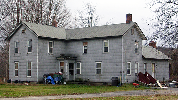
A 2012 photo of a house owned by Gustave Cornelis. This house was located on the corner of Nichols and Woodtick Roads. It was taken down several years ago.
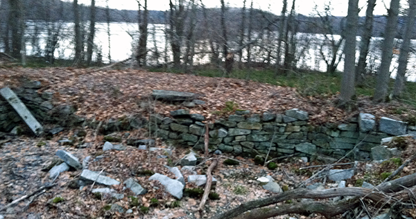
The remains of a foundation from one of the homes that was located on Woodtick Road south of Bound Line Road can still be found along the trail.
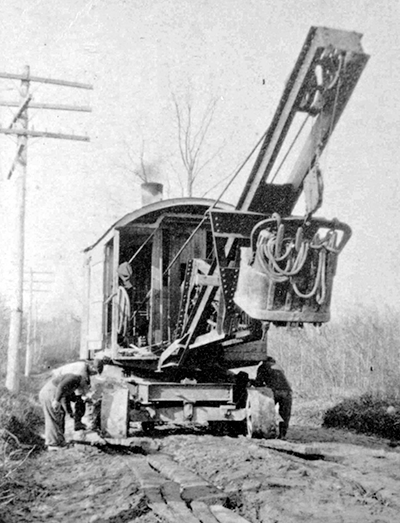
An old steam shovel used in building the upper dam.
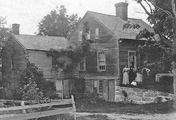
The Timothy Root House was on Fairclough Road (Scovill Road). This beautiful old house was lost when the dam was built.
The Mill Pond Way Logo.
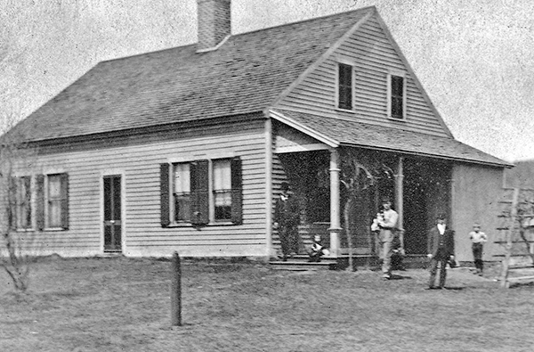
In 1795, Isaac Upson built a house on the north side of Nichols Road next to the Millpond, which today is known as the Isaac Upson House.
To view past installments of the Historical Society News, click here. |
|
|
[Home]
[News]
[Purpose]
[Calendar]
[Museum]
[Membership]
[History]
[Contacts]
[Links]
All material at Wolcott Historical Society Web sites Copyright © 2000-2022 Wolcott Historical Society |