|
|
||||||||||||
 |
 |
|
Wolcott Historical Society News - June 2018 By Florence Goodman In my April and May articles I introduced the Lewis family and the idea of, " what's in a name and who were the people associated with that name?" After perusing many old scrapbooks containing newspaper articles about our town, I came across a March 1939 article from the Waterbury paper titled, "Road Naming Committee Appointed At Annual Town Meeting." I thought this would be a good place to start explaining how Wolcott named some of their early roads.
In early March of 1939 the newly appointed "Road Naming Committee" met at the home of Mrs. John A. Warner (our town clerk from 1931 until 1978). At that meeting they elected Mrs. John F. Norton chairman, Mrs. John A. Warner secretary and Mrs. Claude V. Badger publicity chair. They agreed that the following members would be responsible for one of five sections of the town: Mrs. John B. Wakelee in the west or Spindle Hill area; Mrs. Carl G. Mattson in the south section or Meriden Road area; Mrs. Claude V. Badger the Woodtick area; Mrs. John A. Warner the center of town; and Mrs. John F. Norton the northern section of town. The committee felt it was important to keep in mind the early settlers as well as any historical facts in this process of naming or renaming the town roads.
From their research the committee found that around 1696 the first "travel road" in town was an Indian trail or path, which the people of Farmington used to reach Waterbury. This road crossed the northwest corner of town passing the home of Mrs. Carrie Atkins, which was located in the northern Spindle Hill area. Sometime before 1750 a second road was built and known as the "Twenty Rod Highway" because it was 20 rods wide. It was located in the eastern section of town in the Southington Mountain region and was probably part of the present day Meriden Road.
In 1750 the West Farmington Road was laid out; today it is called Spindle Hill Road. By 1754 the East Farmington Road was established; it was the road from Waterbury to Bristol, but NOT the Route 69 that we know today. This particular road meandered from Waterbury to Bristol on the southern part of today's Route 69, but then it veered off onto several roads to eventually reach the Bristol line. There was Nichols Road named after the Nichols family and blacksmith shop and Munson Road named after the large parcel of land and farm that was owned by the Munson family. An old section of Wolcott Road/Route 69 was renamed Wakelee Road after the Wakelee family that owned a very large parcel of land there. The name suggested for the present day Coe Road was Hotchkiss Road again for the family that resided in the area at an earlier time, but the Coe family also owned a large tract of land there too and that is the name it bears today.
Up until 1934, Route 69 ended at Center Street so travelers had to take Center Street to Woodtick Road and then head north toward Bristol; the section of the road starting at the intersection of Center Street and County Road toward Bristol was called East Bristol Road. It was suggested that the section of today's Center Street from Route 69 to the town green to be called Pound Hill Road because of the cattle pound that was located near the green where stray cattle were held until owners claimed them. The caretaker, William Brown used to collect one dollar per head from the owner.
It was decided to change the name of an old section of Woodtick Road to Garthwait Road because several Garthwait family homes were located there; it still bears that name today. Finch Road was called Baker and or Mayhew Road and it was changed back to its original name, which we know today. They also decide that the name Woodtick Road would run from the Waterbury/Wolcott town line to the northern section of town ending at Route 69, thus abandoning the old section called East Bristol Road.
Keeping history in mind, the committee changed Bergen Road where the Bergen Dairy farm was found to Ransom Hall Road for the Hall family who were the original owners of that land. In 1939 the committee named the road County Road from the Southington border to the center of town onto the south side of the green. Today that road is Center Street and Kenea Avenue. The Kenea family donated the statue of the soldier on the green in memory of their father who fought in the Revolutionary War as a soldier from Wolcott; County Road now ends at Woodtick Road.
Most of us know that Bound Line Road served as the boundary line between Farmington and Waterbury, but did you know that there was a South Bound Lind Road? That was the name of the section of Bound Line Road that ran from Woodtick Road to the Center, west side of the green to Cemetery Road. Cemetery Road was the section of Bound Line Road, which extended past Edgewood Cemetery up Minor's hill and across Route 69 to the Plymouth town line. It was later changed to Bound Line Road and Bound Line Road Ext.
Finally, the committee recommended that the whole stretch of road in the western section of town from the Waterbury town line to the Bristol town line be named Spindle Hill Road for the spindle mill that was found in the region many years ago. The road where the North School was found would be named North Street and both these names still exist today.
It's interesting to see how the committee came up with these names and which ones have changed and which still remain. I will continue with the roads names next month so if you have an interesting road name history or question, please email me at fjgtdg@gmail.com.
(Information for this article was taken from March 10, 1939 article in the Waterbury Republican-American, "Committee Will Name Town Roads"; and March 15, 1939 article in the Waterbury Republican-American, "Early History Kept in Mind In Naming Of Wolcott Roads.")
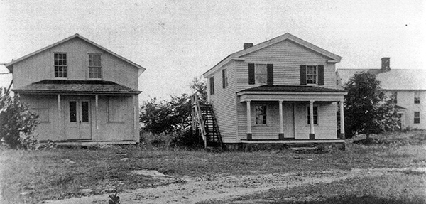
The Wolcott Grange, Town Hall and the Tuttle House in the background in the early 1900s. This would be Kenea Avenue today, but was probably not named when this picture was taken.
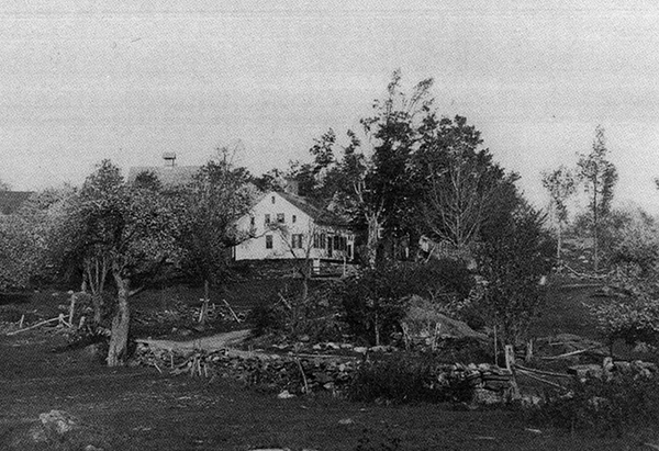
The Pritchard House located on the corner of Minor Road and Center Street today. Notice that Center Street is dirt and bordered by a stonewall.
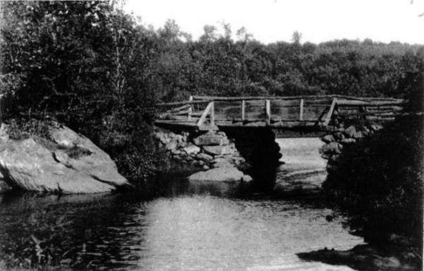
The old wooden bridge crossing the Mad River at Center Street.
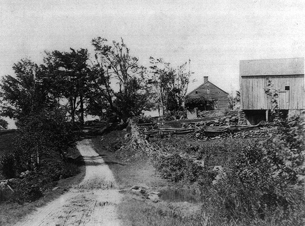
This dirt road would later be named Beach Road. The farm is the old Alcott Homestead where Amos Bronson Alcott grew up. The barn in the foreground on the right is no longer there.
To view past installments of the Historical Society News, click here. |
|
|
[Home]
[News]
[Purpose]
[Calendar]
[Museum]
[Membership]
[History]
[Contacts]
[Links]
All material at Wolcott Historical Society Web sites Copyright © 2000-2018 Wolcott Historical Society |


