|
|
||||||||||||
 |
 |
|
Wolcott Historical Society News - September 2011 By Florence Goodman I thought it fitting this month to write about Wolcott's rivers, streams and reservoirs while the frenzy of Hurricane Irene is still fresh in our minds. Prior to the hurricane the town's reservoirs were lowered to accommodate the large amount of rainwater that was expected with the storm. During and after the storm, the Mad River and its tributaries flowed violently down the hills of Wolcott filling our lakes and reservoirs and in some cases, overflowing their banks. Now try to imagine what this major river and these tributaries looked like 200 years ago without all the debris and undergrowth slowing them down. Since waterpower was the main source of energy then, early entrepreneurs built their mills along their banks to harness this waterpower.
I have observed the Mad River in all types of weather, but most recently I was able to see it as Hurricane Irene passed through our town. If you were able to do the same, I'm sure you can understand why it received that name and why so many mills were built along its banks in the 1800s.
The Mad River originates in the northern section of town near the Bristol line, flows south and southwest into Waterbury and empties into the Naugatuck River. Many of our streams throughout town flow into this river adding to its waterpower. The "Great Mill Place" was found below the falls just south of the intersection of Center Street and Wolcott Road. Wiley Pritchard built a sawmill in this vicinity.
In the western section of town, there is Alcott or Stony Brook, which flows from Spindle Hill into the Mad River following Mad River Road. The second stream in this section of town is Old Tannery Brook, also known as Ash Swamp or Colonel Richards Brook. It flows from Clinton Hill south and enters the Mad River just over the Waterbury line. There was a tannery on this stream operated by Jonathan Bement.
Roaring Brook, found in the northeast section of town, runs southeast and feeds the New Britain Reservoir. There were two mills built along this brook. Also in the northeast is Lindsley Brook, which runs south/southwest along Woodtick Road then flows into the Woodtick Reservoir.
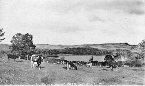
In the southeastern section of town near Southington Mountain, there is Falls Brook. It feeds the Southington Reservoir and then flows down into the Quinnipiac Valley.
Lily Brook, which is found in the southern part of town, flows out of Hitchcock Lake and enters the Mad River in the lower Woodtick area of Wolcott. In 1848, Streat Todd and Thomas Lewis built and operated a sawmill on this brook. There was also a wood-turning mill here operated by a Mr. Chatfield.
The last two streams I will mention were located in the southwestern section of town. Fort Swamp Brook is a small stream that drains into an area called Fort Swamp near the Waterbury/Wolcott border. Originally this was the site of a Tunxis Indian fort, which served as a refuge to protect them from raids by the Mohawks Indians. Finch Brook originates from Tame Buck Hill and Bald Hill and flows west into the Mad River.
In the early 1860s, the Mad River Water Company, a Waterbury-based corporation, began purchasing water rights in surrounding towns and Wolcott was top on their list for water storage facilities. They purchased large tracts of land, which were part of the upper Mad River watershed; by 1874 the Company had constructed three large reservoirs in town: Hitchcock Lakes, Chestnut Hill Reservoir, and Cedar Swamp.
Hitchcock Lakes, which are located in the southeast section of town, were originally farmlands that were owned by Shelton Hitchcock. These lakes were much smaller then and were referred to as the Waterbury Reservoir. Once the Mad River Company purchased the land, these lakes were enlarged to provide more water for the brass industry in Waterbury. By the early 1900s, the land surrounding the lakes became a popular waterfront resort community.
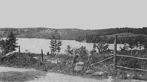
Chestnut Hill Reservoir, which is located in the western section of town, is also call Lyman's Pond and was constructed to control the flow of water into Waterbury mills. This land was part of an early Tunxis Indian hunting ground and many arrowheads have been found here. The land was originally a large swampland called Ash Swamp.
Cedar Lake, which is located in the northern section of town and is shared by the town of Bristol, was originally called Cedar Swamp. The dam that was constructed at the southern section of this lake controls the flow of water through the Mad River and into the Woodtick Reservoir.
It wasn't until 1912 that the Mad River Water Company purchased additional land for the future construction of the Woodtick Reservoir. In 1917, construction of this large man-made pond began. It covered approximately 330 acres of land and was associated with the prominent Scovill Manufacturing Company, which needed large amounts of water to produce brass.
The New Britain Reservoir is located in the northeastern section of Wolcott. In the late 1800s, this land was purchased by the city of New Britain. Prior to that time, a mill was located at this site. Roaring Brook feeds this reservoir.
The Southington Reservoir is located in the southeastern section of Wolcott off of County Road. The town of Southington purchased this property in the 1880s to have a source of water for fire protection for several factories in town. Prior to this it was farmland and the location of a sawmill.
As you can see, our town has an abundance of water sources, which have proven to be beneficial to us and to surrounding towns throughout our history.
(Information for this article was taken from Wolcott Facts and Legends, Wolcott Historical Society; Wolcott, Connecticut 175th Anniversary 1796-1971, John H. Washburne; Old Wolcott, Rose Wakelee Badger; The History of the Town of Wolcott from 1731 to 1874, Samuel Orcutt; and The First 100 Years of The Southington Water Works, Samuel Bowers)
View of Southington Reservoir from Wolcott.
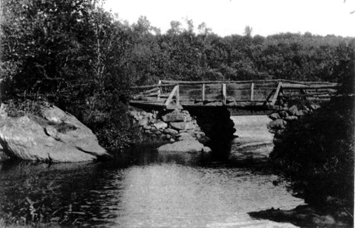
Wiley Pritchard's Mill on Center Street.
Early view of Chestnut Hill Reservoir.
To view past installments of the Wolcott Historical Society News, click here.
|
|
|
[Home]
[News]
[Purpose]
[Calendar]
[Museum]
[Membership]
[History]
[Contacts]
[Links]
All material at Wolcott Historical Society Web sites Copyright © 2000-2011 Wolcott Historical Society |